Marine-Atmospheric Emitted Radiance Interferometer from the high-Arctic ASCOS expedition 2008
Erica Key
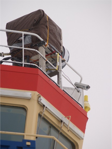
During the ASCOS expedition the temperatures of the cloud-base, ambient air, and surface were very accurately measured using the Marine-Atmospheric Emitted Radiance Interferometer (MAERI) instrument, which also measures downwelling longwave radiation at a very high spectral resolution. The instrument was located at the port bridge-roof wing on the 7th deck of the Icebreaker Oden.
Atmosphere Temperature ASCOS Meteorology High Arctic Arctic boundary layer Arctic clouds Longwave radiation spectra Temperature


Citation
Erica Key (2018) Marine-Atmospheric Emitted Radiance Interferometer from the high-Arctic ASCOS expedition 2008. Dataset version 1. Bolin Centre Database. https://doi.org/10.17043/oden-ascos-2008-interferometer-1
References
Tjernström, M. et al. 2014. The Arctic Summer Cloud Ocean Study (ASCOS): overview and experimental design. Atmospheric Chemistry and Physics, 14, 2823–2869. https://doi.org/10.5194/acp-14-2823-2014
Data description
Marine-Atmospheric Emitted Radiance Interferometer
The Marine-Atmospheric Emitted Radiance Interferometer (M-AERI) was installed on Deck 7 port side forward, with a view of the ice, ocean, and atmosphere at angles directly overhead and at ± 55 degrees. Ninety scans are conducted at each of the 3 environmental viewing angles, as well as at two internal calibration views of ambient and hot blackbodies. Each measurement cycle, which includes the 3 environmental and 2 calibration views, takes ~10 minutes and produces a set of infrared spectra. From the spectra, a highly accurate measurement of sea surface (or ice/snow surface) skin temperature and air temperature is derived.
During precipitation events, including snow flurries, and times of spray over the bridge, the M-AERI may be tarped or the mirror safed to prevent droplets from collecting on the mirror and distorting the retrieved spectra. There were several periods especially during the icebreaking phase of the cruise when the instruments computer froze up, likely due to the vibrations caused by the icebreaking. These would be the only times of data loss, as the sensor operates 24-hours a day from port-to-port. M-AERI air temperature is derived from combination measurements at ± 55 degrees from horizon. A correction was applied to the -55 deg radiance that accounts for the contribution of surface emission to the radiation at this angle. Further information about M-AERI operation can be found in the paper Minnett et al.,. 2001*.
The spectra are logged as daily files, whereas the skin and air temperatures have been collated into one cruise file. Spectral data files can be provided on request. The columns of the temperature file can be described as:
1 day of year ( UTC; yd.decimal yd )
2 hour ( UTC; hour.decimal hour )
3 corrected air temperature ( degrees K )
4 standard deviation of the air temperature
5 mean uncertainty of the air temperature
6 skin temperature ( degrees K )
7 standard deviation of the skin temperature
8 mean uncertainty of the skin temperature
9 latitude
10 longitude
*Minnett, P. J., R. O. Knuteson, F. A. Best, B. J. Osborne, J. A. Hanafin, and O. B. Brown (2001), The Marine-Atmosphere Emitted Radiance Interferometer (M-AERI), a high-accuracy, sea-going infrared spectroradiometer, Journal of Atmospheric and Oceanic Technology, 18, 994-1013.
Comments
The Marine-Atmospheric Emitted Radiance Interferometer (MAERI) instrument measures downwelling longwave radiation at a very high spectral resolution and was located at the port bridge-roof wing on the 7th deck. The isntruments alternates sensing radiation at a 45° upward angle, horizontally straight out from the ship, at a 45° downward angle and into a chilled calibration cavity. In addition to the high-resolution frequency spectra from the upward scans, all scans provide information that can be converted to a radiative temperature. Hence, it measures very accurately both cloud-base, ambient air, and surface temperatures.
Original address: http://www.ascos.se/index.php?q=node/291
Files:
Oden_ASCOS2008_MAERI.txt (517.58 KB)
080802C1.nc (604.25 KB)
080802C2.nc (568.72 KB)
080803C1.nc (1.22 MB)
080803C2.nc (1.15 MB)
080804C1.nc (893.87 KB)
080804C2.nc (844.52 KB)
080805C1.nc (1.34 MB)
080805C2.nc (1.27 MB)
080806C1.nc (1.07 MB)
080806C2.nc (1.01 MB)
080807C1.nc (1.4 MB)
080807C2.nc (1.32 MB)
080808C1.nc (1.44 MB)
080808C2.nc (1.36 MB)
080809C1.nc (1.22 MB)
080809C2.nc (1.15 MB)
080810C1.nc (947.5 KB)
080810C2.nc (895.59 KB)
080811C1.nc (786.6 KB)
080811C2.nc (742.37 KB)
080812C1.nc (1022.59 KB)
080812C2.nc (967.1 KB)
080813C1.nc (1.43 MB)
080813C2.nc (1.35 MB)
080814C1.nc (1.44 MB)
080814C2.nc (1.35 MB)
080815C1.nc (1.44 MB)
080815C2.nc (1.36 MB)
080816C1.nc (1.43 MB)
080816C2.nc (1.35 MB)
080817C1.nc (1.44 MB)
080817C2.nc (1.36 MB)
080818C1.nc (1.44 MB)
080818C2.nc (1.36 MB)
080819C1.nc (1.43 MB)
080819C2.nc (1.35 MB)
080820C1.nc (1.44 MB)
080820C2.nc (1.36 MB)
080821C1.nc (1.41 MB)
080821C2.nc (1.33 MB)
080822C1.nc (1.4 MB)
080822C2.nc (1.32 MB)
080823C1.nc (1.42 MB)
080823C2.nc (1.34 MB)
080824C1.nc (1.44 MB)
080824C2.nc (1.36 MB)
080825C1.nc (1.44 MB)
080825C2.nc (1.36 MB)
080826C1.nc (1.44 MB)
080826C2.nc (1.36 MB)
080827C1.nc (1.44 MB)
080827C2.nc (1.36 MB)
080828C1.nc (1.44 MB)
080828C2.nc (1.36 MB)
080829C1.nc (1.44 MB)
080829C2.nc (1.36 MB)
080830C1.nc (1.44 MB)
080830C2.nc (1.36 MB)
080831C1.nc (1.41 MB)
080831C2.nc (1.33 MB)
080901C1.nc (1.37 MB)
080901C2.nc (1.29 MB)
080902C1.nc (1.19 MB)
080902C2.nc (1.12 MB)
080903C1.nc (625.7 KB)
080903C2.nc (589.15 KB)
080904C1.nc (625.7 KB)
080904C2.nc (589.15 KB)
080905C1.nc (786.6 KB)
080905C2.nc (742.37 KB)
Images
Contact information
Email address
michaelt@misu.su.sePhone number
+46 8 16 3110
Postal address
Michael Tjernström
Department of Meteorology
Stockholm University
SE-106 91 Stockholm
Sweden
GCMD science keywords
Earth science > Atmosphere
GCMD location
Ocean > Arctic Ocean
Status
Completed
Dataset language
English
Project
Arctic Summer Cloud-Ocean Study 2008 (Ascos)
Publisher
Bolin Centre Database
Begin date
2008-08-01
End date
2008-09-08
Dataset version
1
Use limitations
None
DOI
10.17043/oden-ascos-2008-interferometer-1
Published
2018-10-16 16:24:39