Ola Persson, Allen B. White
Cloud and precipitation information data was collected using a ship-based vertically pointing Doppler radar at the S-band, adapted to primarily measure precipitation but can also be used for clouds. The available variables include the radar reflectivity, the mean Doppler velocity of all hydrometeors and the width of the Doppler spectrum, for each measurement volume as a function of height. Full Doppler spectra is available on request.
Download data
Visit web site
Citation
Ola Persson, Allen B. White (2018) S-band radar data from the high-Arctic ASCOS expedition 2008. Dataset version 1. Bolin Centre Database. https://doi.org/10.17043/oden-ascos-2008-radar-1
References
Tjernström, M. et al. 2014. The Arctic Summer Cloud Ocean Study (ASCOS): overview and experimental design. Atmospheric Chemistry and Physics, 14, 2823–2869. https://doi.org/10.5194/acp-14-2823-2014
Data description
This zip_file contains moment data from S-band cloud/precipitation radar on the Oden during ASCOS. Version 1 contains netcdf files of the ~ 2 minute moment data for the vertically pointing radar beam. Version 1 contains data from the drift portion of the cruise (YD214–260; Aug. 1 – Sep. 16), which includes the return portion of the cruise over the Norwegian Sea as well. When the signal was below the minimum detectable signal for the radar, the reflectivity data were assigned a flag of “-99.99,” and the velocity data were assigned a flag of “99.99.”
There occasionally was some radio frequency interference (RFI) present in the Doppler spectra that has not been removed. Also, at the beginning and end of the field campaign, there is data contamination caused by the helicopter that transported personnel to and from the ship.
If there are any questions regarding these data, contact
Dr. Allen B. White
[javascript protected email address]
(303) 497-5155
Or
Dr. Ola Persson
[javascript protected email address]
(303) 497-5078
The data columns are:
Decimal Year Day (UTC )
Latitude (degrees)
Longitude (degrees)
Height_Above_Ship_(km)
Equivalent_Radar_Reflectivity_(dBZe) (missing data = -99.99)
Doppler_vertical_velocity_(meter_per_second_positive_upward) (missing data = 99.99)
Doppler_Spectral_Width_(meter_per_second) (missing data = -99.99)
Comments
Information on clouds was also collected using surface-based remote sensing from two radars and one microwave radiometer. The main source of information comes from the MilliMeter Cloud Radar (MMCR) which is a vertically pointing Ka-band Doppler radar. The second radar is also a vertically pointing Doppler radar, but at the S-band. The MMCR, transmitting at 34 GHz, is very sensitive and ideal for probing low-level clouds, while the S-band radar is more adapted to measuring precipitation but can also be used for clouds.
Both radars provide three main user products for every measuring volume (determined by the increasing width of the radar beam and the height discrimination): The radar reflectivity; essentially the power of the backscatter of the radar beam; 2) The mean Doppler velocity; the mean vertical speed of all the hydrometeors with respect to the radar, and; 3) The width of the Doppler spectra; all hydrometeors within each volume does not have the same vertical velocity.
In addition to the radars a dual-wavelength radiometer was deployed, observing simultaneously the microwave radiation at two wavelengths, allowing the observation of the vertically integrated water vapor (PWV) and cloud liquid water (LWP).
By a combination of the information from the MMCR, the microwave radiometer, the cloud base ceilometer and the soundings, one can also estimate various cloud microphysics parameter can be estimated.
Original address: http://www.ascos.se/index.php?q=node/282
Files:
ASCOS_Sband_Radar_data_v1_netcdf.ZIP (8.35 MB)
Image caption
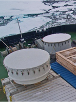
Photo of the cloud remote sensing instruments, showing the S-band radome in the back, the K-band MMCR on top of the radar container, containing all the electronics for both radars and the microwave radiometer at the bottom.
