Tarfala Data
Storglaciären
Storglaciären was first documented by Svenonius who photographed the glacier in 1886 (Svenonius 1910). A few years later the glacer was mapped by the authority of Land Survey. In 1897 the front position was surveyed by Nordgren and Rönnholm for the first time using measuring tape from two marked stones. The front was photographed again in 1904 and 1907 by Borg Mesch. These early photographs show an advancing front. In August 1910 the glacier was mapped using a photogrammetric theodolite by Enquist. Enquist constructed a map in the scale 1:10 000 of the fronts of the glaciers in the Tarfala valley. In 1922 the glacier was photographed again by Odencrantz. His and Enquists photos were later used to construct a map of the Kebnekaise massif in the scale 1:50 000 (STF, 1925). Herrman made a detailed description of the front area and took photographs showing a thinning snout (Herrman, 1931). Between 1930 and 1945 the front was visited a few times in order to survey the change in front position (Mannerfelt, 1940).
Monitoring data
In May 1946 the first survey of snow accumulation was carried out (Schytt, 1947). This survey was the initiation of a long-term investigation of the mass balance of Storglaciären. Since then, detailed surveys of accumulation and ablation are carried out every year by Tarfala Research Station and the mass balance record is the longest in the world.
Time series
Winter mass balance, summer mass balance, net mass balance, equilibrium line altitude and ackumulation area ratio are available as time series in a single file.
Download data
- Calculated mass balance for Storglaciären 1946–2015
- Calculated mass balance for Storglaciären 1946–2015
Annual mass balance data
All annual mass balance data files, one file for each year.
Download data
Data file and figure files in EPS format for a single year.
Download data
- Annual mass balance data
- Ablation gradient
- Net mass balance map
- Summer mass balance map
- Changes in specific mass balance (m) with elevation
- Winter mass balance map
- Snow density
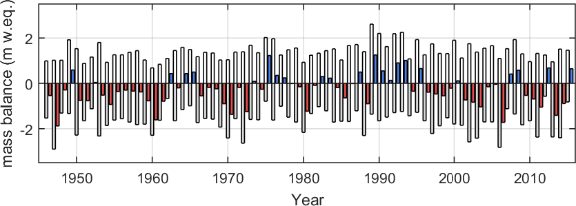
- Time series of the annual mass balance
- Position of snow depth soundings and corresponding winter accumulation values (in metres water equivalent)
- Position of stakes and corresponding summer ablation values (in metres water equivalent)
- Distribution of net mass balance volume (m3) and area (m2) with elevation
Choose year
Graph
A graph of the Storglaciären mass balance record. White bars represent the winter balance and grey bars the summer balance. The net balance is given as blue for postive and red for negative.
Publications

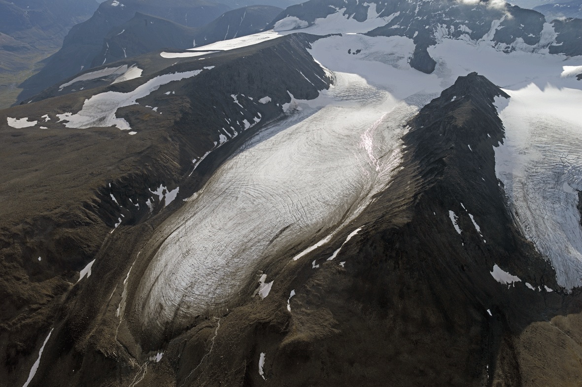
Storglaciären, east of Kebnekaise. Photo: Per Holmlund.
| Location (WGS84) | 67°54'N, 18°34'E |
| Areal extension | 3.0 km2 |