Jakob Kuttenkeuler, Nina Kirchner
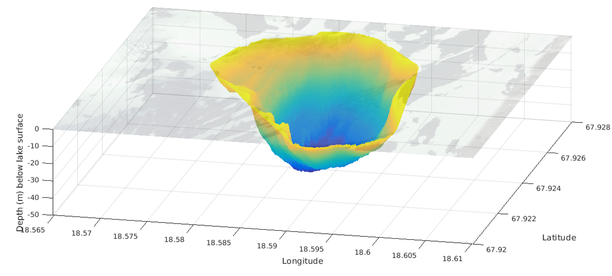
The bathymetry of Lake Tarfala, located in a pro-glacial high alpine environment in the Kebnekaise mountains, northern Sweden, was mapped in September 2016. The mapping was made with an autonomous surface vessel, “ANKA”, designed to map shallow, uncharted waters. The survey had two objectives: (i) to acquire a modern bathymetric dataset of Lake Tarfala that can serve as a reference for future investigations of the lake dynamics. (ii) to test ANKA’s robustness, performance and endurance in a subpolar environment. The dataset includes a comparison with data from an earlier survey conducted in 1959.
Note that this is an outdated revision of the dataset and there is an
updated version.
Citation
Jakob Kuttenkeuler, Nina Kirchner (2017) Bathymetry of Lake Tarfala, northern Sweden. Dataset version 1. Bolin Centre Database. https://doi.org/10.17043/tarfala-kirchner-2017-bathymetry-1
References
Autonomous bathymetric mapping of Lake Tarfala, Arctic Sweden. Kirchner, N., Kuttenkeuler, J., Strandell Erstorp, E., Rosqvist, G., Wennbom, M., Karlin, T. Arktos (in review)
Data description
ANKA data was acquired using an echosounder of type AIRMAR® EchoRange™ Smart™ Sensor, operated at 200kHz. Data is stored in xls files, as longitude, latitude and depth. Approximately 40 000 individual single beam echo sounder pings are included. The data has been cleaned for obvious outliers.
Historical data by Larje and Nyberger (1960) has been digitized and is provided as xlsx files. The dataset, available in one zip-file, includes four data files and one image file:
ANKA_all_soundingsNK.xlsx
ANKA_cleaned_soundingsNK.xlsx
Bathymetry_Tarfala_NK.png
Larje_Nybeger_cropped_soundings_digitized_NK.xlsx
Larje_Nyberger_all_soundings_digitizedNK.xlsx
Comments
Pro-glacial high alpine lakes, like Lake Tarfala, potentially hold preserved sediment archives revealing changes in climatically forced glacier activity and ecosystems. Here, we present the first modern bathymetric dataset of Lake Tarfala, containing more that 38000 depth-soundings. The ANKA dataset replaces the previously best-available dataset, published in 1960 from 257 depth-soundings conducted in 1959. A comparison of the two datasets shows that the map constructed from the 1960 data is surprisingly accurate despite it lacks exact GPS positioning, but that the position of single features, e.g. the deepest point of the lake, depends on the spatial resolution of the bathymetric map. The bathymetric dataset from Lake Tarfala presented here is shared with the community with the aim to provide base data useful in future studies of the lake, as well as to inspire for further autonomous mapping campaigns in sparsely monitored high northern latitude lakes.
Project partners
Jakob Kuttenkeuler, KTH Royal Institute of Technology, Stockholm, jakob[at]kth.se
Nina Kirchner, Stockholm Universtity (SU) and KTH, nina.kirchner[at]natgeo.su.se
Elias Strandell Erstorp, KTH, eliasse[at]kth.se
Gunhild Rosqvist, SU, ninis.rosqvist[at]natgeo.su.se.
Video from mapping campaign
Autonomous Hydrographic Mapping at KTH
GCMD science keywords
Earth science > Terrestrial hydrosphere > Surface water > Lakes
GCMD location
Continent > Europe > Northern Europe > Scandinavia > Sweden
Project
Autonomous bathymetric mapping of Lake Tarfala, Sweden
Publisher
Bolin Centre Database
DOI
10.17043/tarfala-kirchner-2017-bathymetry-1
Published
2017-10-19 13:55:38
