Tarfala Data
Rabots glaciär
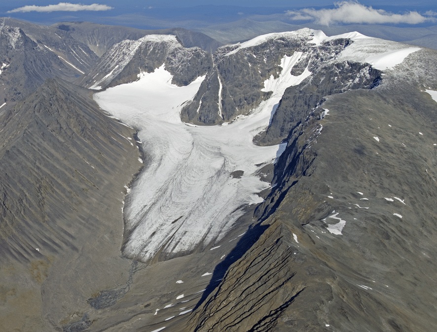
Rabots glaciär is a valley glacier situated on the western side of the Kebnekaise massif. It was first described by Schytt (1947, 1959) and later by Stroeven and van de Val (1987, 1990) and Brugger (1992). It has a gently sloping longitudinal profile mirroring the smooth subglacial valley floor. The accumulation area is split into three cirques. These cirques are orientated WSW, WNW, N giving a complicated flow pattern on the tongue.
Monitoring data
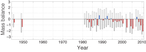
The oldest documentation of the glacier is dated to 1883 when the French mountaineer and geographer Charles Rabot photographed the front while climbing Kebnekaise for the very first time. In 1910 the glacier was visited by Enquist who made a detailed photographic documentation of the entire glacier. The glacier front was next described by Schytt in 1945 while examining potential sites for the long term mass balance series which begun on Storglaciären the year after. Mass balance records exist from the years 1945/46, 1951/52 and 1952/53 (Schytt 1947 and Østrem unpublished). The glacier front was mapped occasionally between 1946 and 1963 and thereafter more or less annually. Since 1981 there is a continuous record of mass balance. Large scale photogrammetric maps are constructed based on aerial photographs from 1959, 1980 and 1990.
The headwall of Rabots glaciär was the location of a catastrophic air plane crash in March 2012 resulting in the loss of human lives and extensive pollution from the air plane's fuel. Monitoring of the hydrocarbon pollution is carried out by Tarfala Research Station.
Time series
Winter mass balance, summer mass balance, net mass balance, equilibrium line altitude and ackumulation area ratio are available as time series in a single file.
Download data
- Calculated mass balance for Rabots glaciär 1982–2011
- Calculated mass balance for Rabots glaciär 1986–2011
Annual mass balance data
Data file and figure files in EPS format for a single year.
Download data
- Annual mass balance data
- Ablation gradient
- Net mass balance map
- Summer mass balance map
- Changes in specific mass balance (m) with elevation
- Winter mass balance map
- Snow density
- Time series of the annual mass balance
- Position of snow depth soundings and corresponding winter accumulation values (in metres water equivalent)
- Position of stakes and corresponding summer ablation values (in metres water equivalent)
- Distribution of net mass balance volume (m3) and area (m2) with elevation
Choose year
Graph
A graph of the Rabots glaciär mass balance record. White bars represent the winter balance and grey bars the summer balance. The net balance is given as blue for postive and red for negative.

Publications


